
PRODUCTS
CONTACT US
TEL: +86-532-85754589,85775618
FAX: E-Mail
E-MAIL: tlead.net@gmail.com; tlead.net@hotmail.com

Measuring Instruments — Compass Series
Keywords: Metal Compass, Prismatic Compass, Military Compass, Lensatic Compass, Compass with Clinometer
Precision Bearings, Map Work, and Field Calculations in One Metal Compass.
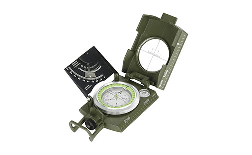
The 4074 is a rugged metal prismatic compass built for serious field navigation. A 360° pivoting dial and reading prism let you take precise bearings and marching directions, while an integrated clinometer measures slope and height differences. Distance-measuring notches on the glass and a full set of built-in calculation tables make it possible to work out distance, height, and position directly in the field — no separate tools required.
1. Graduated metric scale
2. 360° pivoting dial
3. Wind rose
4. North line with north arrow
5. Glass
6. Distance-measuring notches
7. Aiming line
8. Cover
9. Case
10. Hinge
11. Reading lens or prism
12. Holding ring
13. Level bubble
14. Thread and tripod mount
15. Central support
16. Reading adjustable eyepiece
17. Clinometer
1. Reading Marching Direction — Sight an object through the notch, aiming line, and reading lens or prism; the value on the wind rose gives the marching direction and azimuth of the object.
2. Following a Set Direction — With a known marching direction, look through the reading system and turn until that value appears on the graduated scale, then walk that heading.
3. Map Orientation — Align the centimeter-marked edge with the nearest meridian on the map, then rotate the map until the north-seeking needle lines up with the notch on the glass — the map is now correctly oriented to the ground.
4. Plotting a Marching Direction on the Map — Draw a line from your position to your destination, align the compass edge to that line, then read and follow the resulting marching direction to your target — repeating with auxiliary points for longer routes.
5. Position Fixing on the Map — Take bearings on two well-visible points from your location, plot both lines on the oriented map, and the intersection marks your position.
6. Using the Clinometer — Release the pendulum, aim at the upper or lower edge of the target through the reading lens, and read the slope or height difference in degrees or percent once the pendulum settles.
7. Measuring Distance on the Ground — Measure the angle between two points using the compass, then apply the built-in calculation table to convert that angle into a ground distance.
8. Measuring the Height of an Object — Read the inclination in degrees or percent with the clinometer, then use the table's pendence and height/distance columns together with the known distance to calculate the object's height.
9. Measuring Distance from a Known Height or Width — Invert the same calculation: with an object's height or width already known, the measured angle gives you the distance to that object.
10. Measuring Distance with the Scale-Marked Glass — Count the notches between two targets on the glass's horizontal measuring line (each notch equals 10 units), then divide the known distance between the two targets by that unit count and multiply by 1000 to find the distance to the observer.
Use this reference table with the clinometer and compass readings to convert between angle units and to calculate pendence (slope %) and height-to-distance ratio in the field.
| I Angle 0–360 |
II Angle 0–6400 |
III Angle 0–400 |
IV Pendence % |
V Height/Distance |
|---|---|---|---|---|
| 1 | 18 | 1 | 2 | 1/6 |
| 2 | 35 | 2 | 3 | 1/30 |
| 3 | 53 | 3 | 5 | 1/20 |
| 4 | 71 | 4 | 7 | 2/30 |
| 5 | 89 | 5 | 9 | 7/80 |
| 6 | 107 | 6 | 10 | 1/10 |
| 7 | 125 | 7 | 12 | 1/8 |
| 8 | 142 | 8 | 15 | 1/7 |
| 10 | 178 | 9 | 18 | 1/6 |
| 12 | 219 | 11 | 21 | 1/5 |
| 14 | 250 | 13 | 25 | 1/4 |
| 17 | 302 | 16 | 30 | 3/10 |
| 18 | 320 | 19 | 33 | 1/3 |
| 20 | 355 | 20 | 36 | 3/8 |
| 22 | 391 | 25 | 40 | 2/5 |
| 24 | 426 | 27 | 45 | 4/9 |
| 27 | 480 | 30 | 50 | 1/2 |
| 31 | 551 | 35 | 60 | 3/5 |
| 34 | 604 | 38 | 66 | 2/3 |
| 35 | 622 | 39 | 70 | 7/10 |
| 37 | 658 | 41 | 75 | 3/4 |
| 40 | 711 | 45 | 84 | 5/6 |
| 42 | 747 | 47 | 90 | 9/10 |
| 45 | 800 | 50 | 100 | 1/1 |
| 50 | 889 | 56 | 120 | 1+1/5 |
The 4074 metal compass is suited for land navigation and field survey work, including military and tactical use, orienteering, forestry and geology fieldwork, land surveying, and general outdoor navigation where accurate bearings, map orientation, and distance or height calculations are needed.